


Double click image to zoom in


Click image to open expanded view


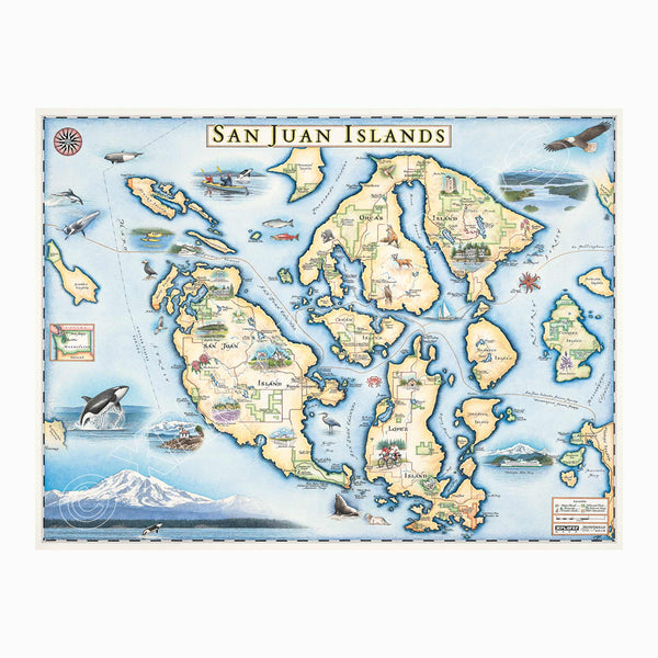
Original hand-drawn pen and ink/watercolor story map of the San Juan Islands located in the upper Puget Sound off the coast of Washington and Canada showcasing unique marine and coastal landscapes, features, and wildlife.
While made up of a total of 170 islands, the main islands of the archipelago are San Juan Island, Lopez Island and Orcas Island. The history of the islands is marked as the homeland of a group of indigenous tribes collectively known as the North Straits Coast Salish. After encountering English settlers, the tribes’ populations declined due to exposure to smallpox and other diseases to which they were not immune. Over centuries the islands would come to be a desirable territory to the young country, the United States, as well as Britain which led to a war over claim of the islands. Today, the islands are part of Washington state and attract national and international visitors each year to enjoy the stunning Pacific Northwest views of landscapes, experience endless recreation opportunities, spot remarkable wildlife as well as enjoy the temperate weather that creates a laid back lifestyle and culture.
Across the islands are a variety of historic landmarks and 17 state parks for visitors to explore the island as well as the coastal life and views from the island including: Moran State Park, Lime Kiln Point State Park, Spencer Spit State Park, Obstruction Pass State as well as other state parks. Other major locations stand out such as: San Juan Island National Historic Park English Camp, Pelinda Lavender Farm, San Juan Vineyards, American Camp & Pickett’s Monument, Observation Tower, Hotel de Haro, Rock Harbor & Rock Harbor Resort, Liv Winery, Rosario Resort and more. In addition to the state parks and landmark features are a variety of natural preservers across the islands to protect and maintain the unchanged environment and wildlife.
The serenity of the islands, their tranquil lakes and the abundance of channels between the islands are the perfect dream destination for an outdoor and nature enthusiast to explore the forest and lakes of the islands as well as observe quintessential northwest plants and wildlife such as: breaching whales, seals, sea lions, blue herons, salmon striped sun stars, red foxes, bald eagles and more.
The lithograph print by Chris Robitaille of Explorer maps is 24’’ wide by 18’’ tall.
* The framed map is for retail purchase only. Xplorer Maps does not offer wholesale pricing on framed maps.
Montana's Flathead Lake larch Frame - 10%of the larch logs originally intended as railroad ties for the Great Northern Railroad sunk to the bottom of Flathead Lake, MT. These over 100-year-old logs have been dive-located, dredged, dried, cured, planed, scraped, sawn, sanded, and shaped into reclaimed heritage wood frames exclusively for Xplorer Maps.
Hand-Scraped Montana Pine - Montana forest-harvested pine frame. For that rustic look, each frame is hand-scraped.
All frames are equipped with conservation clear glass, which is guaranteed to block 99% of ultraviolet rays. Upgrade to Museum glass, which ensures 99% UV protection but also provides ZERO GLARE - this is the quality glass you would find in gallery settings.
Our on-line store is open 24/7 and we ship Monday through Friday, excluding some holidays. Orders received for products without shipping restrictions on its product page will ship the same business day when received before 12:00 p.m. PST. Orders in high demand will have an estimated production time listed on its product page and will ship according to the date listed.
The Xplorer Maps Warehouse Team strives to ship every order within 1 business day.
For custom orders (including framing), please allow 3-4 weeks for shipping.
Xplorer Maps ships all over the world, but prices and shipping times vary according to state, country, and the weight of items purchased. International recipients are solely responsible for any fees such as, but not limited to, VAT or import duties.
All prices will be charged according to your destination at check-out. This information is shown before your credit card is charged and you can click on the "calculate shipping charges" once an item has been placed in the cart to see the exact shipping based on your zip code.
We ship with UPS and USPS. Expedited shipping options are available at checkout.
Please be aware that despite our prompt shipping, factors beyond our control may occasionally lead to delays in the arrival of your order. For additional questions regarding shipping please email us at: warehouse@xplorermaps.com
This map is perfect. Love the size and colors in print.
Email: Info@xplorermaps.com
Brick-and-Mortar Address: 1245 S 3rd ST W; Missoula, MT 59801
Phone: 406-546-4972
Warehouse Address: 500 S Inez ST; Missoula MT 59801
© 2024, Xplorer Maps


