


Double click image to zoom in


Click image to open expanded view


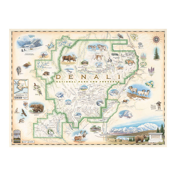
This 24" x 18" unframed lithographic map art print features an original hand-drawn pen and ink/watercolor story map of Denali National Park, home to the tallest mountain in North America. Known for its towering peaks and unique wildlife, Denali's breathtaking landscapes are unmatched in the United States.
Located 240 miles north of Anchorage, Denali National Park is nestled in the Alaska Range. The park's centerpiece, Denali, rises to 20,310 feet and divides the area into two regions: the southern portion with expansive glaciers and the northern area of scrub vegetation and spruce woodland.
The park is a haven for wildlife, attracting visitors from around the globe with sightings of Grizzly bears, Dall sheep, moose, and more. Visitors can also enjoy native plants like Fireweed and Forget-me-nots.
Key attractions include the Talkeetna Ranger Station, Denali Visitor Center, and the Eielson Visitor Center.
This vibrant lithograph by Chris Robitaille of Xplorer Maps captures the essence of Denali National Park's natural beauty and adventure.
Are you looking for a custom matted and framed piece? Pick from Montana hand-scraped pine or reclaimed Flathead Lake larch. In addition, you can choose between green or blue mats.
* The framed map is for retail purchase only. Xplorer Maps does not offer wholesale pricing on framed maps.
Hand-Scraped Montana Pine - Montana forest-harvested pine frame. For that rustic look, each frame is hand-scraped.
All frames are equipped with conservation clear glass, which is guaranteed to block 99% of ultraviolet rays. Upgrade to Museum glass, which ensures 99% UV protection but also provides ZERO GLARE - this is the quality glass you would find in gallery settings.
Our on-line store is open 24/7 and we ship Monday through Friday, excluding some holidays. Orders received for products without shipping restrictions on its product page will ship the same business day when received before 12:00 p.m. PST. Orders in high demand will have an estimated production time listed on its product page and will ship according to the date listed.
The Xplorer Maps Warehouse Team strives to ship every order within 1 business day.
For custom orders (including framing), please allow 3-4 weeks for shipping.
Xplorer Maps ships all over the world, but prices and shipping times vary according to state, country, and the weight of items purchased. International recipients are solely responsible for any fees such as, but not limited to, VAT or import duties.
All prices will be charged according to your destination at check-out. This information is shown before your credit card is charged and you can click on the "calculate shipping charges" once an item has been placed in the cart to see the exact shipping based on your zip code.
We ship with UPS and USPS. Expedited shipping options are available at checkout.
Please be aware that despite our prompt shipping, factors beyond our control may occasionally lead to delays in the arrival of your order. For additional questions regarding shipping please email us at: warehouse@xplorermaps.com
Sign up for our newsletter
Email: Info@xplorermaps.com
Brick-and-Mortar Address: 1245 S 3rd ST W; Missoula, MT 59801
Phone: 406-546-4972
Warehouse Address: 500 S Inez St; Missoula MT 59801
© 2025, Xplorer Maps Powered by Shopify