


Bundle & Save
Hand-Drawn Map Bundle - 4 for $100
$120.00


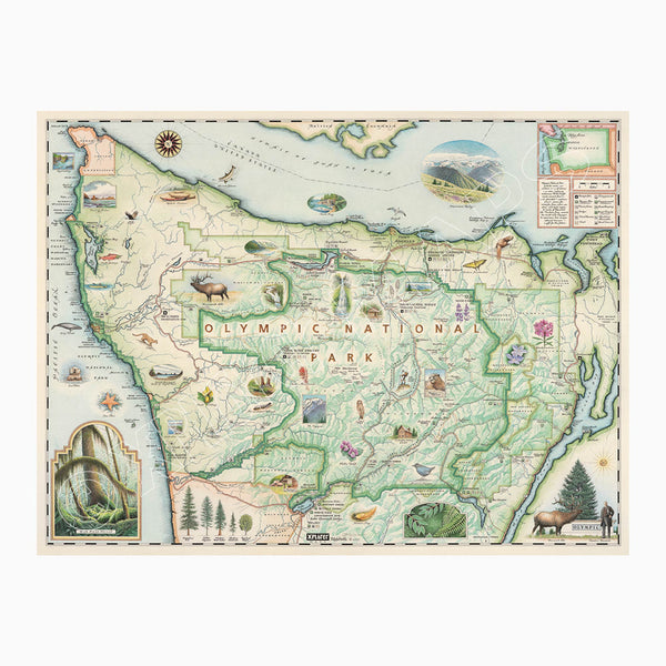
This 24” x 18” unframed lithographic art print features an original hand-illustrated map of Olympic National Park, created in pen and ink with watercolor by Xplorer Maps artist Chris Robitaille.
Spanning nearly one million acres across Washington’s Olympic Peninsula, the park is defined by dramatic ecological diversity — from rugged Pacific coastline to temperate rainforest and glacier-capped peaks. Ocean winds and heavy precipitation from the Pacific shape this unique landscape, creating one of the most varied ecosystems in North America.
The map captures 73 miles of protected coastline, including sea stacks, driftwood-strewn beaches, and landmarks such as Cape Flattery and Point of the Arches. Inland, Mount Olympus rises to 7,980 feet, surrounded by glaciers that feed wild river systems. The lush Hoh Rain Forest, nourished by up to 12 feet of annual rainfall, is illustrated with its moss-draped trees and dense undergrowth.
Hurricane Ridge, just outside Port Angeles, is woven into the composition, reflecting the park’s accessible alpine vistas and year-round recreation.
Marine and terrestrial wildlife bring the map to life — gray whales, sea otters, cougars, Roosevelt elk, and diverse plant species highlight the park’s extraordinary biodiversity.
Blending cartographic precision with artistic storytelling, this piece captures the wild contrast and layered beauty that define Olympic National Park.
Product Details
Dimensions: 24” × 18”
Orientation: Horizontal
Print Type: Fine art lithograph
Artwork by: Chris Robitaille, Co-Founder of Xplorer Maps
Ships rolled in protective tube