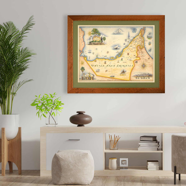
As rich in oil as it is in history, the United Arab Emirates boasts the 7th world’s largest oil and natural gas reserves and thus is most notably known for these and the associated lifestyle. But the country’s history and culture is a far better story. Humans have inhabited the land since 5500 B.C. and in most recent centuries were under Portuguese, Ottoman and British control until its independence in the late 1960’s. Civilization thrived throughout its history from early copper trading to fishing industry to the pearling industry that thrived until the end of the second world war.
The natural flora and fauna of the United Emirates is mostly desert with the oases growing date palms, acacia and eucalyptus trees. In the desert the flora is very sparse and consists of grasses and thornbushes. Sharks, dolphins, whales, tuna and other marine life roam the Arabian gulf waters while few animals like the Arabian onyx and leopards call the inland deserts home.
The Xplorer Maps United Arab Emirates map captures a great deal of this history and geography in this beautifully depicted, antique and old-world style, hand-illustrated map.
The UAE map is approximately 24" wide x 18" tall and is printed with eco-friendly inks on enhanced matte paper. This is an Epson Ultra Premium Presentation matte finish 10.3 ml paper that displays exceptionally well.
*Limited quantities available
Looking for a custom matted and framed piece? Choose from Montana hand-scraped pine, antique maple burl, rustic Montana barn wood or reclaimed Flathead Lake larch. (Learn more about the Flathead Lake Larch here). You can also choose between green and blue mats. All frames come standard with conservation clear glass which is guaranteed 99% UV protection. Upgrade to Museum glass which also guarantees 99% UV protection but also provides ZERO GLARE - this is the quality glass you would find in gallery settings. You can also request a complete customization by emailing us.
Email usAll Xplorer Maps lithographic maps are printed on heavy-duty, 80 lb. cover stock using only soy-based inks and 50% post-consumer product. The medium for Giclee prints is 100% cotton, MUSEO MAX, heavy rag with absolutely no optical brighteners. These giclee prints represent the finest original artwork reproduction in the industry and will appreciate in value approximately 5% annually for a true investment in art.
Every print is shipped in our unique and distinct “illustrated tube” that is safe and convenient for shipping, and travel as they fit in all standard carry-on-luggage.
A lot of map art is simply stock or "open source" imagery with a logo or small piece of custom art overlayed so that it can then be marketed as "original, custom, art". Xplorer Maps is different. Every single line, letter and image has been intricately rendered entirely by hand. Each is unique and original to every new map we create. These maps are truly custom and one of a kind!
The medium used by world-renowned illustrator Chris Robitaille for these hand-drawn maps is pen & ink with multiple layers of watercolor washes. Depending on the depth of detail in the map being rendered, the actual art process takes anywhere from 5-8 weeks.
The end result is an entirely custom, unique and original piece of art that has been fully vetted for "educational merit, historical and geographic accuracy and cultural relevance.
$60.00
Touted as the "most private migration safari experience on Earth", Singita Grumeti guests experience both...
$60.00
London continued to make its mark from the artists of the Tudor period like Shakespeare...
$60.00
Each region in Mallorca has its own unique and stunning appeal - the northeast for...