


Double click image to zoom in


Click image to open expanded view
Bundle & Save
Hand-Drawn Map Bundle - 4 for $100
$120.00


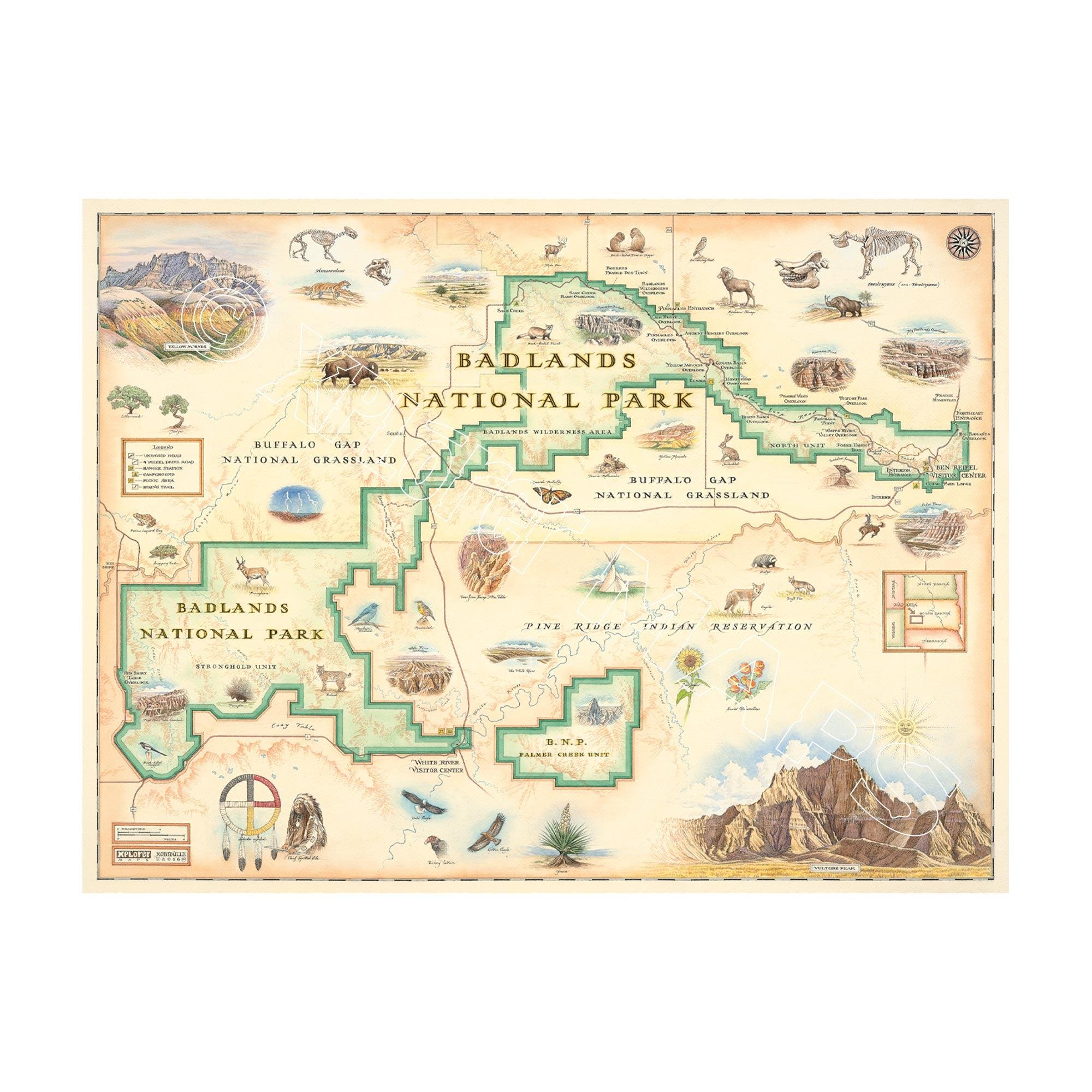
This 24” x 18” unframed lithographic art print features an original hand-illustrated map of Badlands National Park, created in pen and ink with watercolor by Xplorer Maps artist Chris Robitaille.
Located in southwestern South Dakota, the Badlands are defined by sharply eroded buttes, layered rock formations, and towering spires carved by millions of years of deposition and erosion. The map captures the park’s dramatic striations and vibrant mineral bands that give the landscape its distinctive texture and color.
Highlighted regions include the Stronghold Unit, the Badlands Wilderness, and the Northern Unit, which is co-managed with the Oglala Lakota Tribe. Scenic viewpoints such as Pinnacles Overlook and Sheep Mountain Table are thoughtfully woven into the composition, reflecting the sweeping scale of this prairie-meets-desert terrain.
Wildlife including bison, elk, prairie dogs, and the endangered black-footed ferret animate the landscape, while fossil discoveries of prehistoric mammals such as Brontothere and Hoplophoneus underscore the park’s paleontological significance.
Blending cartographic precision with artistic storytelling, this piece captures the raw geology, cultural depth, and expansive horizons that define Badlands National Park.
Product Details
Dimensions: 24” × 18”
Orientation: Horizontal
Print Type: Fine art lithograph
Artwork by: Chris Robitaille, Co-Founder of Xplorer Maps
Ships rolled in protective tube
Our on-line store is open 24/7 and we ship Monday through Friday, excluding some holidays. Orders received for products without shipping restrictions on its product page will ship the same business day when received before 12:00 p.m. PST. Orders in high demand will have an estimated production time listed on its product page and will ship according to the date listed.
The Xplorer Maps Warehouse Team strives to ship every order within 1 business day.
For custom orders (including framing), please allow 3-4 weeks for shipping.
Xplorer Maps ships all over the world, but prices and shipping times vary according to state, country, and the weight of items purchased. International recipients are solely responsible for any fees such as, but not limited to, VAT or import duties.
All prices will be charged according to your destination at check-out. This information is shown before your credit card is charged and you can click on the "calculate shipping charges" once an item has been placed in the cart to see the exact shipping based on your zip code.
We ship with UPS and USPS. Expedited shipping options are available at checkout.
Please be aware that despite our prompt shipping, factors beyond our control may occasionally lead to delays in the arrival of your order. For additional questions regarding shipping please email us at: store@xplorermaps.com