


Double click image to zoom in

Click image to open expanded view
Bundle & Save
Hand-Drawn Map Bundle - 4 for $100
$120.00


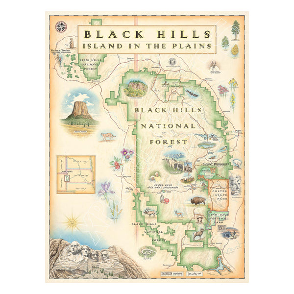
This 18” x 24” unframed lithographic art print features an original hand-illustrated map of Black Hills National Forest and Mount Rushmore, created in pen and ink with watercolor by Xplorer Maps artist Chris Robitaille.
Located in western South Dakota, the Black Hills rise dramatically from the surrounding plains, forming a landscape of granite peaks, dense pine forests, and rolling meadows. Long considered sacred by the Lakota Sioux, the region carries deep cultural and historical significance.
The map highlights iconic landmarks including Mount Rushmore National Memorial and Custer State Park, known for its scenic drives, granite spires, and roaming bison herds. Historic Deadwood, Spearfish Canyon, and other notable destinations are woven into the composition, reflecting the area’s blend of natural beauty and frontier history.
Outdoor enthusiasts will recognize the George S. Mickelson Trail, stretching over 100 miles through tunnels, bridges, and forested terrain — a favorite for hiking and biking.
Wildlife such as bison, elk, mountain goats, and bald eagles reinforce the region’s ecological richness, while dramatic rock formations define its rugged character.
Blending cartographic detail with artistic storytelling, this piece honors the natural grandeur and cultural heritage of the Black Hills.
Product Details
Dimensions: 18” × 24”
Orientation: Vertical
Print Type: Fine art lithograph
Artwork by: Chris Robitaille, Co-Founder of Xplorer Maps
Ships rolled in protective tube
Our on-line store is open 24/7 and we ship Monday through Friday, excluding some holidays. Orders received for products without shipping restrictions on its product page will ship the same business day when received before 12:00 p.m. PST. Orders in high demand will have an estimated production time listed on its product page and will ship according to the date listed.
The Xplorer Maps Warehouse Team strives to ship every order within 1 business day.
For custom orders (including framing), please allow 3-4 weeks for shipping.
Xplorer Maps ships all over the world, but prices and shipping times vary according to state, country, and the weight of items purchased. International recipients are solely responsible for any fees such as, but not limited to, VAT or import duties.
All prices will be charged according to your destination at check-out. This information is shown before your credit card is charged and you can click on the "calculate shipping charges" once an item has been placed in the cart to see the exact shipping based on your zip code.
We ship with UPS and USPS. Expedited shipping options are available at checkout.
Please be aware that despite our prompt shipping, factors beyond our control may occasionally lead to delays in the arrival of your order. For additional questions regarding shipping please email us at: store@xplorermaps.com