


Double click image to zoom in

Click image to open expanded view
Bundle & Save
Hand-Drawn Map Bundle - 4 for $100
$120.00

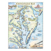
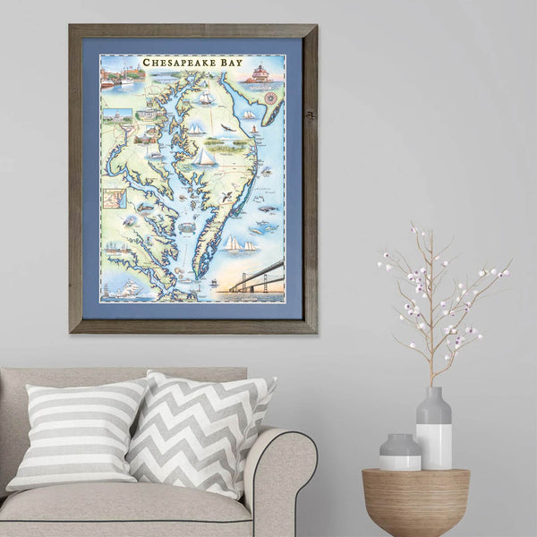
This 18” x 24” unframed lithographic art print features an original hand-illustrated map of Chesapeake Bay, created in pen and ink with watercolor by Xplorer Maps artist Chris Robitaille.
Spanning 191 miles from Havre de Grace, Maryland to Virginia Beach, Virginia, Chesapeake Bay is the largest estuary in the United States — a defining waterway of the Mid-Atlantic. The map captures the interconnected rivers, inlets, and shoreline communities that shape the region’s maritime identity.
Major cities including Baltimore, Annapolis, and Washington, D.C. are thoughtfully illustrated, alongside iconic landmarks such as the U.S. Capitol and historic coastal lighthouses. The sweeping Chesapeake Bay Bridge anchors the composition, symbolizing the connection between the bay’s northern and southern shores.
Native wildlife — from great blue herons and blue crabs to coastal dolphins — bring movement and character to the artwork, reflecting the bay’s ecological richness and long-standing maritime traditions.
Blending geographic accuracy with artistic storytelling, this piece serves as a meaningful tribute for sailors, historians, watermen, and anyone connected to the Chesapeake region.
Dimensions: 18” × 24”
Orientation: Vertical
Print Type: Fine art lithograph
Artwork by: Chris Robitaille, Co-Founder of Xplorer Maps
Ships: Rolled in protective tube
Our on-line store is open 24/7 and we ship Monday through Friday, excluding some holidays. Orders received for products without shipping restrictions on its product page will ship the same business day when received before 12:00 p.m. PST. Orders in high demand will have an estimated production time listed on its product page and will ship according to the date listed.
The Xplorer Maps Warehouse Team strives to ship every order within 1 business day.
For custom orders (including framing), please allow 3-4 weeks for shipping.
Xplorer Maps ships all over the world, but prices and shipping times vary according to state, country, and the weight of items purchased. International recipients are solely responsible for any fees such as, but not limited to, VAT or import duties.
All prices will be charged according to your destination at check-out. This information is shown before your credit card is charged and you can click on the "calculate shipping charges" once an item has been placed in the cart to see the exact shipping based on your zip code.
We ship with UPS and USPS. Expedited shipping options are available at checkout.
Please be aware that despite our prompt shipping, factors beyond our control may occasionally lead to delays in the arrival of your order. For additional questions regarding shipping please email us at: store@xplorermaps.com