


Double click image to zoom in


Click image to open expanded view
Bundle & Save
Hand-Drawn Map Bundle - 4 for $100
$120.00


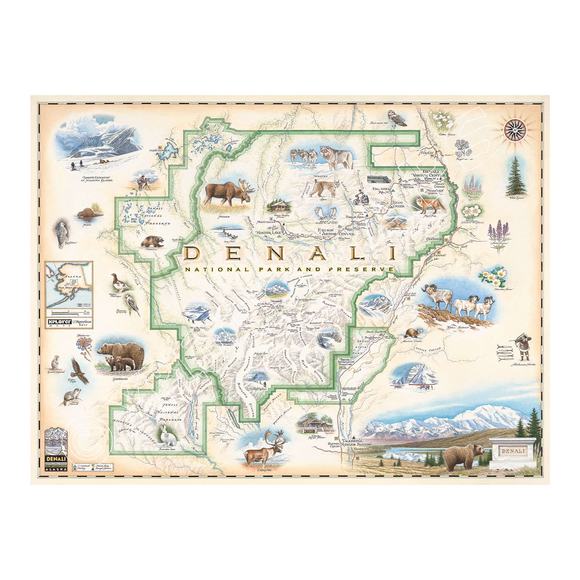
This 24” x 18” unframed lithographic art print features an original hand-illustrated map of Denali National Park, created in pen and ink with watercolor by Xplorer Maps artist Chris Robitaille.
Located approximately 240 miles north of Anchorage within the Alaska Range, Denali National Park is home to the tallest mountain in North America. Denali rises to 20,310 feet, dominating the skyline and dividing the park into two distinct ecological regions — glacier-covered southern slopes and the tundra and spruce woodlands to the north.
The map captures the vast scale and dramatic topography of the region, from braided river valleys and expansive glaciers to alpine ridgelines and open tundra. Landmarks such as the Denali Visitor Center, Eielson Visitor Center, and Talkeetna Ranger Station are thoughtfully integrated into the composition.
Denali’s wildlife is central to its identity. Grizzly bears, Dall sheep, moose, caribou, and wolves roam freely across the landscape, while native flora such as fireweed and Alaska’s state flower, the forget-me-not, add seasonal color.
Blending cartographic precision with artistic storytelling, this piece reflects the scale, solitude, and wild character that define Denali — a landscape where nature remains dominant and untamed.
Product Details
Dimensions: 24” × 18”
Orientation: Horizontal
Print Type: Fine art lithograph
Artwork by: Chris Robitaille, Co-Founder of Xplorer Maps
Ships rolled in protective tube
Our on-line store is open 24/7 and we ship Monday through Friday, excluding some holidays. Orders received for products without shipping restrictions on its product page will ship the same business day when received before 12:00 p.m. PST. Orders in high demand will have an estimated production time listed on its product page and will ship according to the date listed.
The Xplorer Maps Warehouse Team strives to ship every order within 1 business day.
For custom orders (including framing), please allow 3-4 weeks for shipping.
Xplorer Maps ships all over the world, but prices and shipping times vary according to state, country, and the weight of items purchased. International recipients are solely responsible for any fees such as, but not limited to, VAT or import duties.
All prices will be charged according to your destination at check-out. This information is shown before your credit card is charged and you can click on the "calculate shipping charges" once an item has been placed in the cart to see the exact shipping based on your zip code.
We ship with UPS and USPS. Expedited shipping options are available at checkout.
Please be aware that despite our prompt shipping, factors beyond our control may occasionally lead to delays in the arrival of your order. For additional questions regarding shipping please email us at: store@xplorermaps.com