


Double click image to zoom in


Click image to open expanded view
Bundle & Save
Hand-Drawn Map Bundle - 4 for $100
$120.00

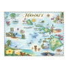


Discover the beauty and spirit of the Hawaiian Islands with this 24" × 18" unframed fine art lithograph, featuring an original hand-illustrated map by Xplorer Maps Co-Founder and artist Chris Robitaille.
Created in pen and ink with watercolor, this vibrant map showcases the unique character of Hawaiʻi's major islands, highlighting volcanic landscapes, lush rainforests, cascading waterfalls, pristine beaches, native wildlife, and rich cultural landmarks. From the dramatic cliffs of Kauaʻi and the beaches of Maui to the volcanic wonders of Hawaiʻi Island, every illustration reflects the islands' extraordinary natural beauty and aloha spirit.
The artwork features Kauaʻi, Oʻahu, Molokaʻi, Lānaʻi, Maui, Kahoʻolawe, and Hawaiʻi (Big Island), along with iconic landmarks including Diamond Head, Waikīkī, Nā Pali Coast, Haleakalā National Park, Hawaiʻi Volcanoes National Park, Akaka Falls, Mauna Loa, Kīlauea, historic ʻIolani Palace, colorful reef life, humpback whales, sea turtles, native birds, and tropical flora.
Whether Hawaiʻi is your favorite vacation destination, a place you once called home, or a dream adventure waiting to happen, this museum-quality lithograph brings the islands' beauty into any home or office.
Ships: Rolled in protective tube
Our on-line store is open 24/7 and we ship Monday through Friday, excluding some holidays. Orders received for products without shipping restrictions on its product page will ship the same business day when received before 12:00 p.m. PST. Orders in high demand will have an estimated production time listed on its product page and will ship according to the date listed.
The Xplorer Maps Warehouse Team strives to ship every order within 1 business day.
For custom orders (including framing), please allow 3-4 weeks for shipping.
Xplorer Maps ships all over the world, but prices and shipping times vary according to state, country, and the weight of items purchased. International recipients are solely responsible for any fees such as, but not limited to, VAT or import duties.
All prices will be charged according to your destination at check-out. This information is shown before your credit card is charged and you can click on the "calculate shipping charges" once an item has been placed in the cart to see the exact shipping based on your zip code.
We ship with UPS and USPS. Expedited shipping options are available at checkout.
Please be aware that despite our prompt shipping, factors beyond our control may occasionally lead to delays in the arrival of your order. For additional questions regarding shipping please email us at: store@xplorermaps.com