


Bundle & Save
Hand-Drawn Map Bundle - 4 for $100
$120.00

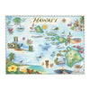

This 24” x 18” unframed lithographic art print features an original hand-drawn pen-and-ink watercolor story map of Hawaiʻi by Xplorer Maps artist Chris Robitaille.
Formed by a volcanic hot spot in the Pacific Ocean, Hawaiʻi’s eight-island chain — Hawaiʻi, Maui, Kahoʻolawe, Lānaʻi, Molokaʻi, Oʻahu, Kauaʻi, and Niʻihau — rises from deep ocean waters into some of the most diverse and ecologically rich landscapes on earth.
The map highlights iconic destinations across the islands, including Puʻuhonua o Hōnaunau and Kaloko-Honokōhau National Historical Parks on Hawaiʻi Island, Haleakalā National Park and the Seven Sacred Pools of Maui, Kalaupapa National Historical Park on Molokaʻi, Pearl Harbor National Memorial and Honolulu on Oʻahu, and the dramatic Nā Pali Coast of Kauaʻi.
Marine life and native flora — from green sea turtles and humpback whales to vibrant tropical blooms — are thoughtfully woven into the composition, reflecting the islands’ extraordinary biodiversity.
Blending cartographic precision with artistic storytelling, this piece serves as a meaningful tribute to Hawaiʻi’s landscapes, history, and spirit.
Dimensions: 24” × 18”
Orientation: Vertical
Print Type: Fine art lithograph
Artwork by: Chris Robitaille, Co-Founder of Xplorer Maps
Ships: Rolled in protective tube