


Double click image to zoom in


Click image to open expanded view
Bundle & Save
Hand-Drawn Map Bundle - 4 for $100
$120.00

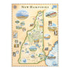

This 18” x 24” unframed lithographic art print features an original hand-illustrated map of New Hampshire, created in pen and ink with watercolor by Xplorer Maps artist Chris Robitaille.
From the granite peaks of the White Mountains to the rocky Atlantic shoreline, the map captures the rugged beauty and historic character of the Granite State. Concord, Manchester, and Portsmouth anchor the composition, while smaller communities and scenic routes add geographic richness.
At the heart of the design lies the White Mountain National Forest, including Mount Washington — accessible by the historic Cog Railway — and the winding Kancamagus Highway, renowned for its vibrant fall foliage. Lake Winnipesaukee and alpine waterways reflect the state’s deep connection to outdoor recreation, from hiking and skiing to boating and fishing.
Historic coastal towns such as Portsmouth and Dover, including landmarks like the John Paul Jones House, are thoughtfully woven into the artwork, balancing New Hampshire’s revolutionary past with its enduring wilderness.
Blending cartographic precision with artistic storytelling, this piece serves as a meaningful tribute for outdoor enthusiasts, New England travelers, and anyone connected to the landscapes of northern New England.
Dimensions: 18” × 24”
Orientation: Horizontal
Print Type: Fine art lithograph
Artwork by: Chris Robitaille, Co-Founder of Xplorer Maps
Ships: Rolled in protective tube
Our on-line store is open 24/7 and we ship Monday through Friday, excluding some holidays. Orders received for products without shipping restrictions on its product page will ship the same business day when received before 12:00 p.m. PST. Orders in high demand will have an estimated production time listed on its product page and will ship according to the date listed.
The Xplorer Maps Warehouse Team strives to ship every order within 1 business day.
For custom orders (including framing), please allow 3-4 weeks for shipping.
Xplorer Maps ships all over the world, but prices and shipping times vary according to state, country, and the weight of items purchased. International recipients are solely responsible for any fees such as, but not limited to, VAT or import duties.
All prices will be charged according to your destination at check-out. This information is shown before your credit card is charged and you can click on the "calculate shipping charges" once an item has been placed in the cart to see the exact shipping based on your zip code.
We ship with UPS and USPS. Expedited shipping options are available at checkout.
Please be aware that despite our prompt shipping, factors beyond our control may occasionally lead to delays in the arrival of your order. For additional questions regarding shipping please email us at: store@xplorermaps.com