


Double click image to zoom in


Click image to open expanded view
Bundle & Save
Hand-Drawn Map Bundle - 4 for $100
$120.00


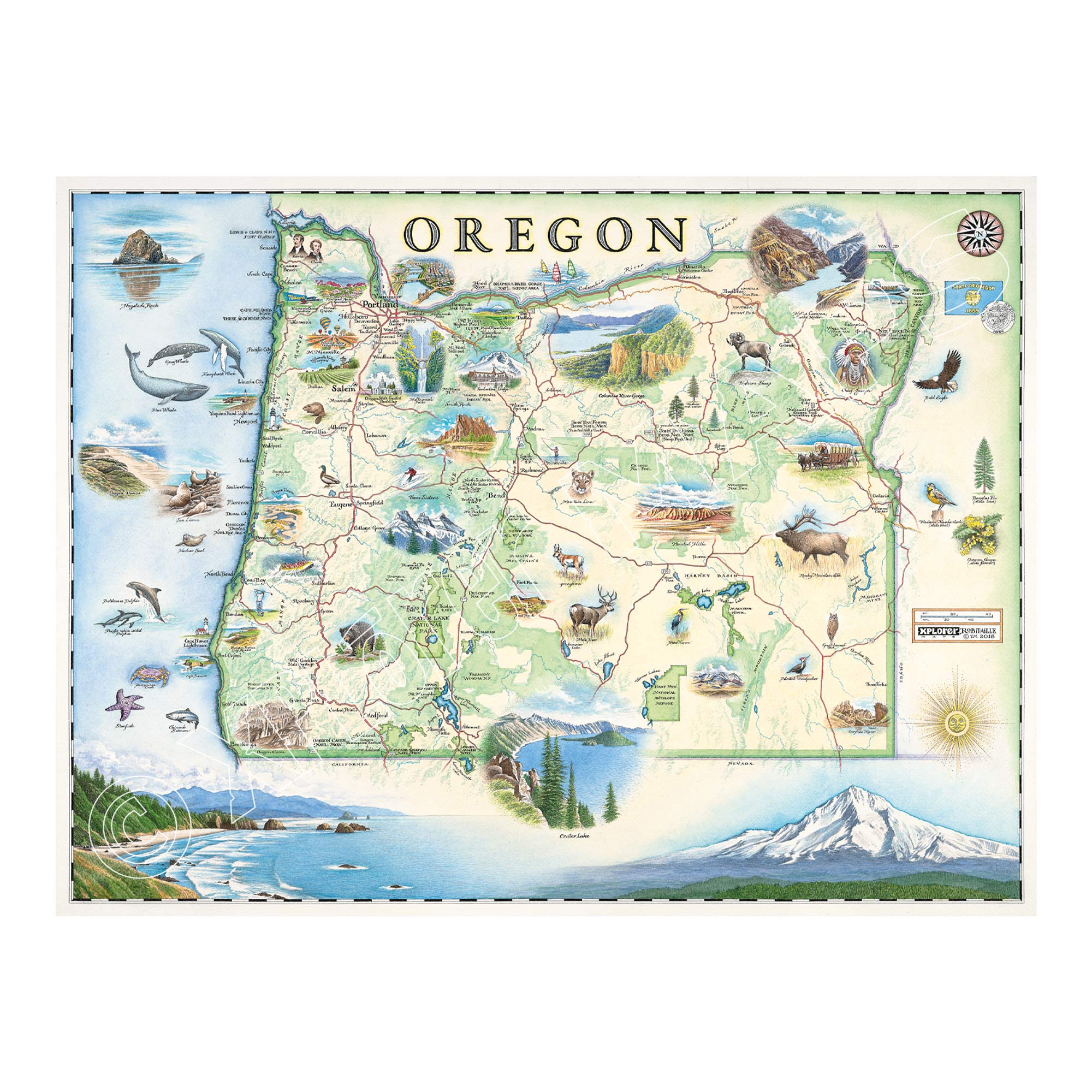
This 24” x 18” unframed lithographic art print features an original hand-illustrated map of Oregon, created in pen and ink with watercolor by Xplorer Maps artist Chris Robitaille.
Defined by dramatic ecological contrasts, Oregon stretches from 363 miles of rugged Pacific coastline to high desert plateaus east of the Cascade Range. The Coast Range and Cascade Mountains divide the state into two distinct ecoregions — the lush, temperate rainforests of the west and the dry, wide-open landscapes shaped by rain shadow in the east.
Major cities including Portland, Salem, Eugene, Medford, and Bend are thoughtfully integrated into the composition, alongside iconic destinations such as Crater Lake, Multnomah Falls, Fort Clatsop, and the Painted Hills. The coastline features historic lighthouses and thriving marine ecosystems, home to gray whales, humpback whales, and seabirds riding coastal winds.
Inland, places like Hart Mountain National Antelope Refuge showcase Oregon’s expansive wilderness and diverse wildlife, from mule deer to bald eagles. Cultural landmarks and seasonal traditions — including vineyards and tulip festivals — add depth to the state’s character.
Blending cartographic precision with artistic storytelling, this piece captures Oregon’s wild coast, volcanic peaks, forests, and high desert in one cohesive visual narrative.
Product Details
Dimensions: 24” × 18”
Orientation: Horizontal
Print Type: Fine art lithograph
Artwork by: Chris Robitaille, Co-Founder of Xplorer Maps
Ships rolled in protective tube
Our on-line store is open 24/7 and we ship Monday through Friday, excluding some holidays. Orders received for products without shipping restrictions on its product page will ship the same business day when received before 12:00 p.m. PST. Orders in high demand will have an estimated production time listed on its product page and will ship according to the date listed.
The Xplorer Maps Warehouse Team strives to ship every order within 1 business day.
For custom orders (including framing), please allow 3-4 weeks for shipping.
Xplorer Maps ships all over the world, but prices and shipping times vary according to state, country, and the weight of items purchased. International recipients are solely responsible for any fees such as, but not limited to, VAT or import duties.
All prices will be charged according to your destination at check-out. This information is shown before your credit card is charged and you can click on the "calculate shipping charges" once an item has been placed in the cart to see the exact shipping based on your zip code.
We ship with UPS and USPS. Expedited shipping options are available at checkout.
Please be aware that despite our prompt shipping, factors beyond our control may occasionally lead to delays in the arrival of your order. For additional questions regarding shipping please email us at: store@xplorermaps.com