


Double click image to zoom in


Click image to open expanded view
Bundle & Save
Hand-Drawn Map Bundle - 4 for $100
$120.00


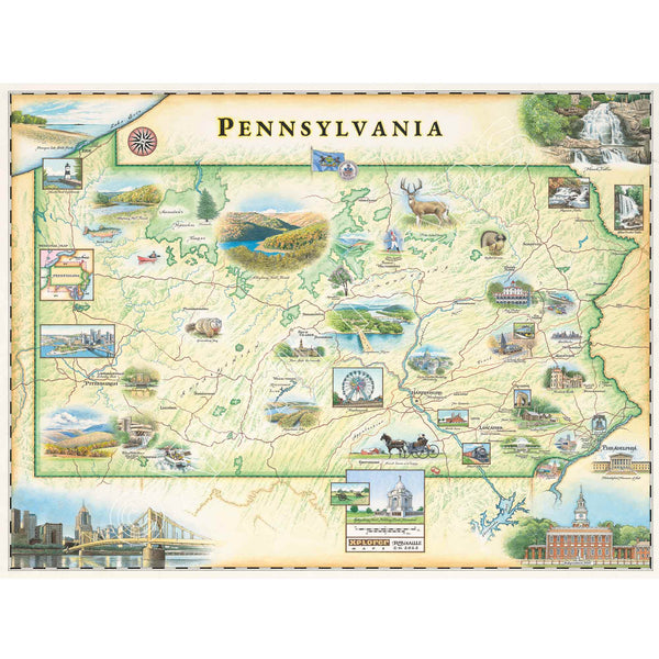
This 24” x 18” unframed lithographic art print features an original hand-illustrated map of Pennsylvania by Xplorer Maps artist Chris Robitaille. Created in pen and ink with watercolor detail, the artwork captures the landscapes and landmarks that define the Keystone State.
From Philadelphia — the birthplace of American democracy — to the historic fields of Gettysburg, the map highlights iconic sites including the Liberty Bell, Independence Hall, and pivotal Revolutionary and Civil War landmarks. The Appalachian Mountains sweep across the composition, while the rolling farmlands of Lancaster County reflect Pennsylvania’s agricultural heritage.
Urban centers, historic corridors, and natural terrain are thoughtfully woven together, offering a visual narrative of the state’s political legacy, industrial roots, and enduring cultural identity.
Blending cartographic precision with artistic storytelling, this piece serves as a meaningful tribute for history enthusiasts, proud Pennsylvanians, and collectors of place-
Bring the beauty and history of the Keystone State into your home with this 24" × 18" hand-drawn lithographic map of Pennsylvania by Xplorer Maps. Created in pen and ink with watercolor by Xplorer Maps Co-Founder Chris Robitaille, this original illustration celebrates Pennsylvania's scenic mountains, forests, rivers, covered bridges, historic sites, charming towns, wildlife, and iconic destinations from Philadelphia to Pittsburgh.
Every detail reflects the landscapes, history, and outdoor adventures that make Pennsylvania one of America's most diverse states. Whether displayed in a home, cabin, office, or vacation retreat, this fine art print is both a conversation piece and a lasting keepsake.
Our on-line store is open 24/7 and we ship Monday through Friday, excluding some holidays. Orders received for products without shipping restrictions on its product page will ship the same business day when received before 12:00 p.m. PST. Orders in high demand will have an estimated production time listed on its product page and will ship according to the date listed.
The Xplorer Maps Warehouse Team strives to ship every order within 1 business day.
For custom orders (including framing), please allow 3-4 weeks for shipping.
Xplorer Maps ships all over the world, but prices and shipping times vary according to state, country, and the weight of items purchased. International recipients are solely responsible for any fees such as, but not limited to, VAT or import duties.
All prices will be charged according to your destination at check-out. This information is shown before your credit card is charged and you can click on the "calculate shipping charges" once an item has been placed in the cart to see the exact shipping based on your zip code.
We ship with UPS and USPS. Expedited shipping options are available at checkout.
Please be aware that despite our prompt shipping, factors beyond our control may occasionally lead to delays in the arrival of your order. For additional questions regarding shipping please email us at: store@xplorermaps.com