


Bundle & Save
Hand-Drawn Map Bundle - 4 for $100
$120.00


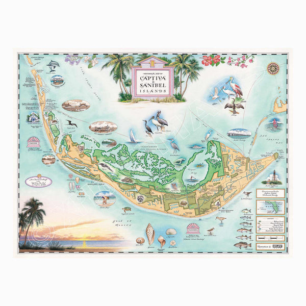
This 24” x 18” unframed lithographic art print features an original hand-illustrated map of Sanibel & Captiva Islands, created in pen and ink with watercolor by Xplorer Maps artist Chris Robitaille.
Located along Florida’s Gulf Coast, these barrier islands are celebrated for their pristine beaches, turquoise waters, and world-famous shelling. The map captures the distinctive east–west orientation of Sanibel Island — a rare geographic feature that helps collect the seashells that wash ashore from the Gulf of Mexico.
Rich in history, the islands were once home to the Calusa people before Spanish explorers arrived in the 1500s. Folklore of pirate José Gaspar and the naming of Captiva Island add layers of legend to the region’s coastal story. By the late 19th century, the islands developed as agricultural communities before evolving into beloved destinations known for wildlife, conservation, and natural beauty.
The map highlights key landmarks including the J.N. “Ding” Darling National Wildlife Refuge, the historic Sanibel Lighthouse, and quiet stretches of shoreline that define the islands’ relaxed character. Mangrove estuaries, native bird species, and marine life are woven into the composition, celebrating the area’s ecological richness.
Blending cartographic detail with artistic storytelling, this piece captures the coastal charm, conservation spirit, and timeless appeal of Sanibel and Captiva.
Product Details
Dimensions: 24” × 18”
Orientation: Horizontal
Print Type: Fine art lithograph
Artwork by: Chris Robitaille, Co-Founder of Xplorer Maps
Ships rolled in protective tube