


Bundle & Save
Hand-Drawn Map Bundle - 4 for $100
$120.00


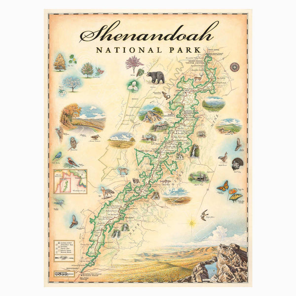
This 18” x 24” unframed lithographic art print features an original hand-illustrated map of Shenandoah National Park, created in pen and ink with watercolor by Xplorer Maps artist Chris Robitaille.
Located in Virginia along the crest of the Blue Ridge Mountains, Shenandoah stretches more than 105 miles from Front Royal in the north to Rockfish Gap in the south. Just 75 minutes from Washington, D.C., the park offers a sweeping wilderness corridor anchored by Skyline Drive and a long, scenic section of the Appalachian Trail.
The map highlights signature landmarks including Hawksbill Mountain, the park’s highest peak, Stony Man Mountain, Big Meadows Lodge, and the cascading waterfalls of Whiteoak Canyon. Rolling ridgelines, forested hollows, and overlooks are thoughtfully woven into the composition, reflecting the park’s rhythm of elevation and valley.
Shenandoah’s rich ecosystems support a wide range of wildlife, from black bears and bobcats to red-shouldered hawks and migrating monarch butterflies. Seasonal color — especially the park’s renowned autumn foliage — defines the landscape and brings the artwork to life.
Blending cartographic precision with artistic storytelling, this piece captures the quiet beauty, accessibility, and Appalachian character that make Shenandoah a beloved national park.
Product Details
Dimensions: 18” × 24”
Orientation: Vertical
Print Type: Fine art lithograph
Artwork by: Chris Robitaille, Co-Founder of Xplorer Maps
Ships rolled in protective tube