


Double click image to zoom in


Click image to open expanded view
Bundle & Save
Hand-Drawn Map Bundle - 4 for $100
$120.00


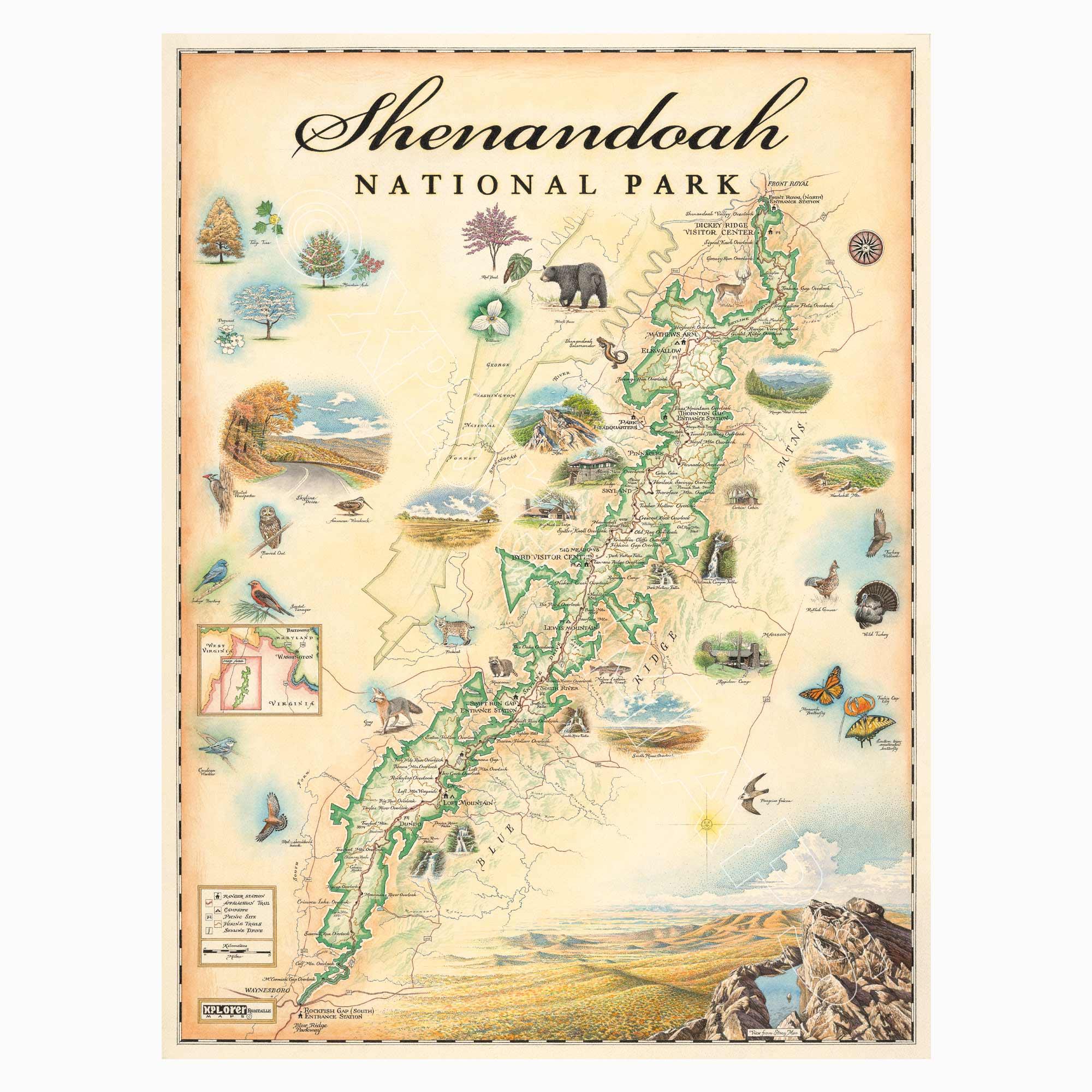
This 18” x 24” unframed lithographic art print features an original hand-illustrated map of Shenandoah National Park, created in pen and ink with watercolor by Xplorer Maps artist Chris Robitaille.
Located in Virginia along the crest of the Blue Ridge Mountains, Shenandoah stretches more than 105 miles from Front Royal in the north to Rockfish Gap in the south. Just 75 minutes from Washington, D.C., the park offers a sweeping wilderness corridor anchored by Skyline Drive and a long, scenic section of the Appalachian Trail.
The map highlights signature landmarks including Hawksbill Mountain, the park’s highest peak, Stony Man Mountain, Big Meadows Lodge, and the cascading waterfalls of Whiteoak Canyon. Rolling ridgelines, forested hollows, and overlooks are thoughtfully woven into the composition, reflecting the park’s rhythm of elevation and valley.
Shenandoah’s rich ecosystems support a wide range of wildlife, from black bears and bobcats to red-shouldered hawks and migrating monarch butterflies. Seasonal color — especially the park’s renowned autumn foliage — defines the landscape and brings the artwork to life.
Blending cartographic precision with artistic storytelling, this piece captures the quiet beauty, accessibility, and Appalachian character that make Shenandoah a beloved national park.
Product Details
Dimensions: 18” × 24”
Orientation: Vertical
Print Type: Fine art lithograph
Artwork by: Chris Robitaille, Co-Founder of Xplorer Maps
Ships rolled in protective tube
Our on-line store is open 24/7 and we ship Monday through Friday, excluding some holidays. Orders received for products without shipping restrictions on its product page will ship the same business day when received before 12:00 p.m. PST. Orders in high demand will have an estimated production time listed on its product page and will ship according to the date listed.
The Xplorer Maps Warehouse Team strives to ship every order within 1 business day.
For custom orders (including framing), please allow 3-4 weeks for shipping.
Xplorer Maps ships all over the world, but prices and shipping times vary according to state, country, and the weight of items purchased. International recipients are solely responsible for any fees such as, but not limited to, VAT or import duties.
All prices will be charged according to your destination at check-out. This information is shown before your credit card is charged and you can click on the "calculate shipping charges" once an item has been placed in the cart to see the exact shipping based on your zip code.
We ship with UPS and USPS. Expedited shipping options are available at checkout.
Please be aware that despite our prompt shipping, factors beyond our control may occasionally lead to delays in the arrival of your order. For additional questions regarding shipping please email us at: store@xplorermaps.com