


Double click image to zoom in


Click image to open expanded view

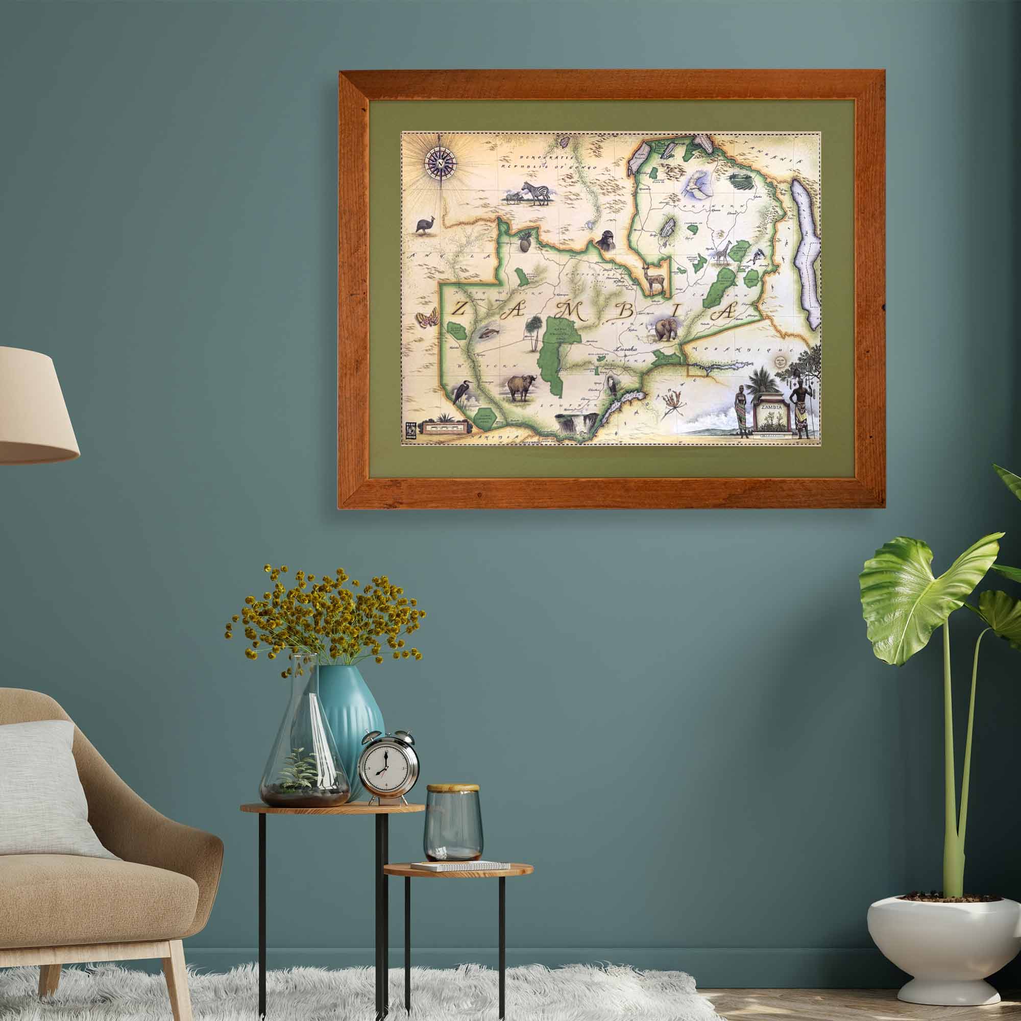
This 24” x 18” unframed lithographic art print features an original hand-illustrated map of Zambia, created in pen and ink with watercolor by Chris Robitaille, Co-Founder of Xplorer Maps.
This piece is especially significant — it is one of the first ten maps Chris created in the late 1990s, marking the early artistic foundation of what would become Xplorer Maps. Limited stock remains available. Please allow approximately three weeks for delivery.
The map captures Zambia’s vast and varied landscapes, from sweeping savannas to powerful river systems. Intricately illustrated wildlife — zebras, elephants, monkeys, Cape buffalo, and more — animate the terrain, celebrating the country’s extraordinary biodiversity.
Renowned national parks including Kafue, North Luangwa, South Luangwa, and Sioma Ngwezi are woven into the composition, each representing some of Africa’s most important conservation landscapes. The Zambezi River flows prominently through the artwork, guiding the eye toward one of the world’s most awe-inspiring natural wonders: Victoria Falls.
The capital city of Lusaka is also featured, reflecting Zambia’s cultural and historical depth alongside its natural grandeur.
Blending artistic storytelling with geographic precision, this map is both a decorative heirloom and a tribute to Zambia’s wildlife, landscapes, and heritage.
Product Details
Dimensions: 24” × 18”
Orientation: Horizontal
Print Type: Fine art lithograph
Artwork by: Chris Robitaille, Co-Founder of Xplorer Maps
Limited early-edition design
Ships rolled in protective tube
Please allow 3 weeks for delivery
Our on-line store is open 24/7 and we ship Monday through Friday, excluding some holidays. Orders received for products without shipping restrictions on its product page will ship the same business day when received before 12:00 p.m. PST. Orders in high demand will have an estimated production time listed on its product page and will ship according to the date listed.
The Xplorer Maps Warehouse Team strives to ship every order within 1 business day.
For custom orders (including framing), please allow 3-4 weeks for shipping.
Xplorer Maps ships all over the world, but prices and shipping times vary according to state, country, and the weight of items purchased. International recipients are solely responsible for any fees such as, but not limited to, VAT or import duties.
All prices will be charged according to your destination at check-out. This information is shown before your credit card is charged and you can click on the "calculate shipping charges" once an item has been placed in the cart to see the exact shipping based on your zip code.
We ship with UPS and USPS. Expedited shipping options are available at checkout.
Please be aware that despite our prompt shipping, factors beyond our control may occasionally lead to delays in the arrival of your order. For additional questions regarding shipping please email us at: store@xplorermaps.com