


Double click image to zoom in


Click image to open expanded view
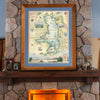
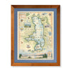

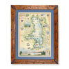

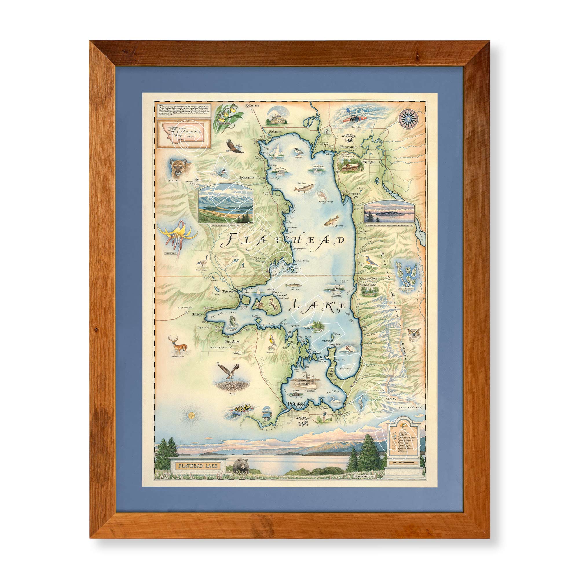
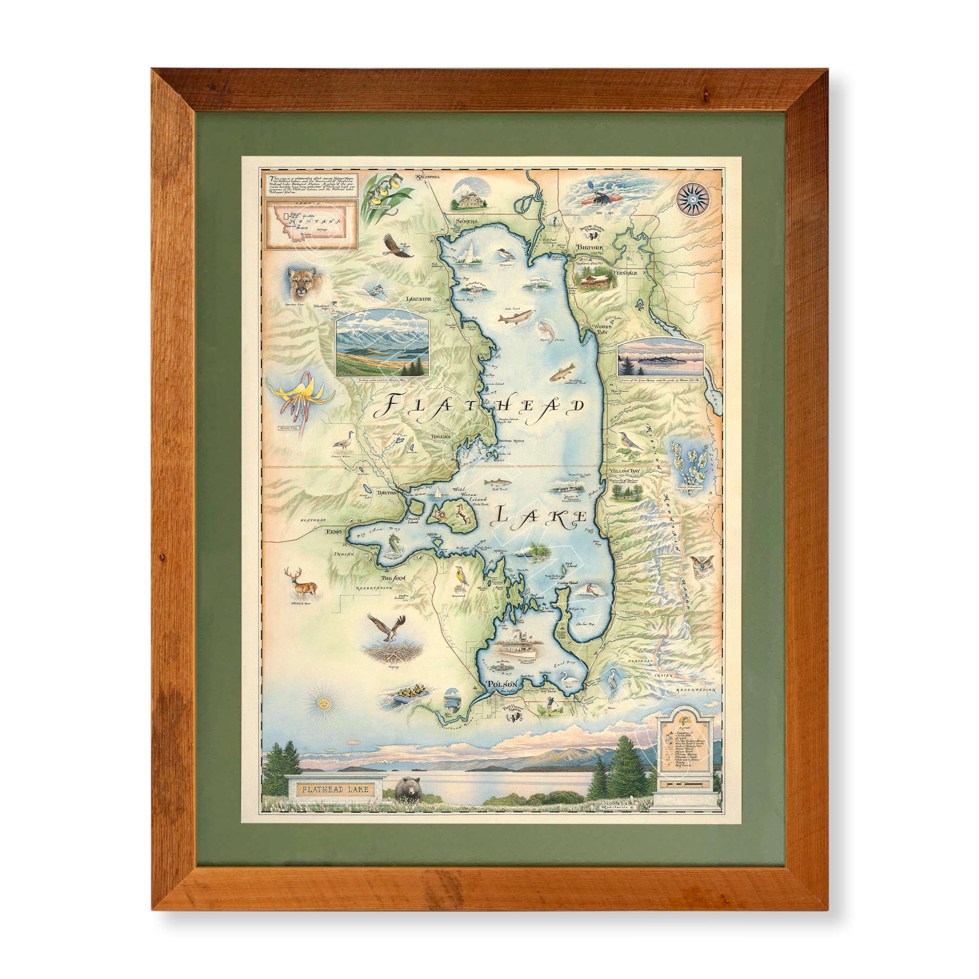
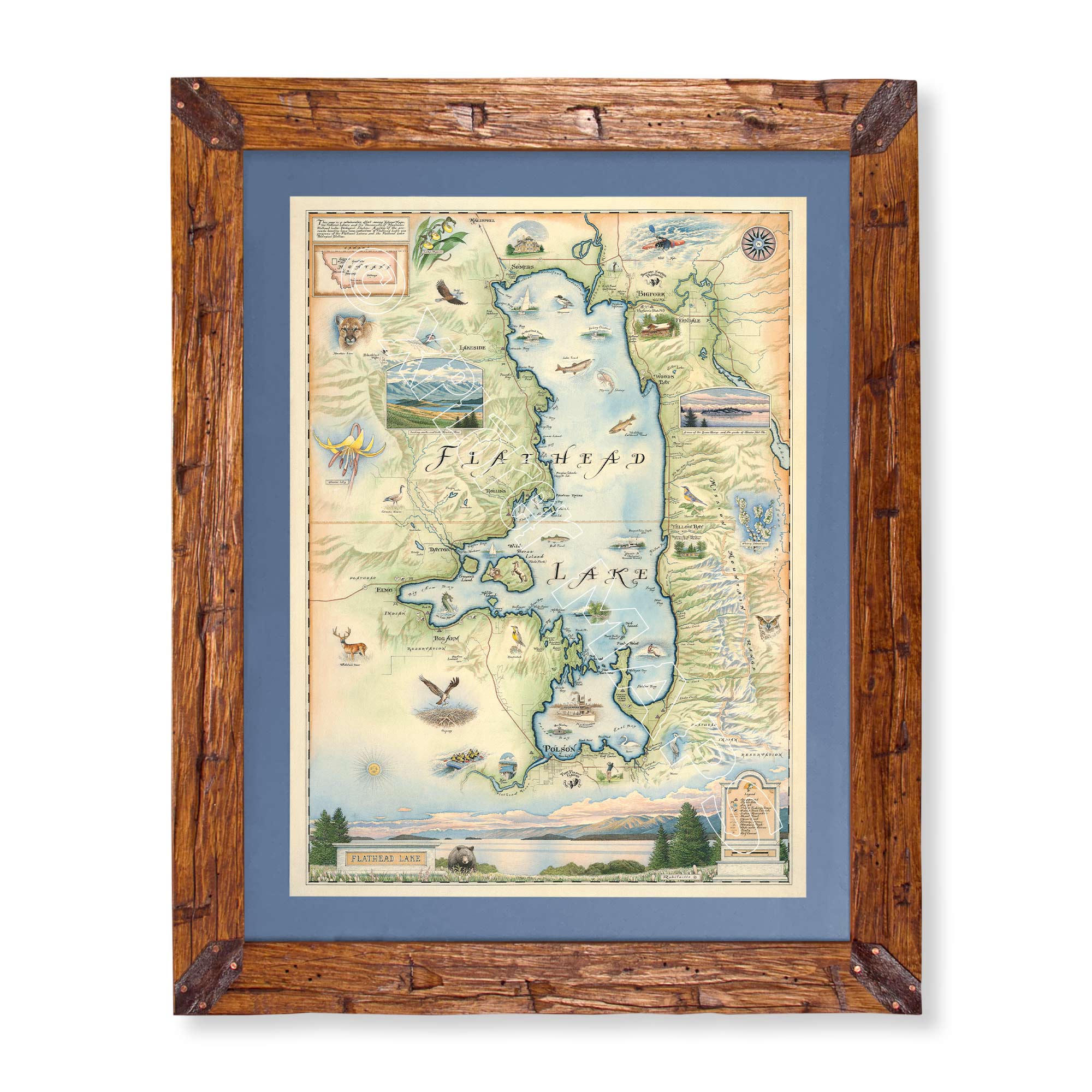
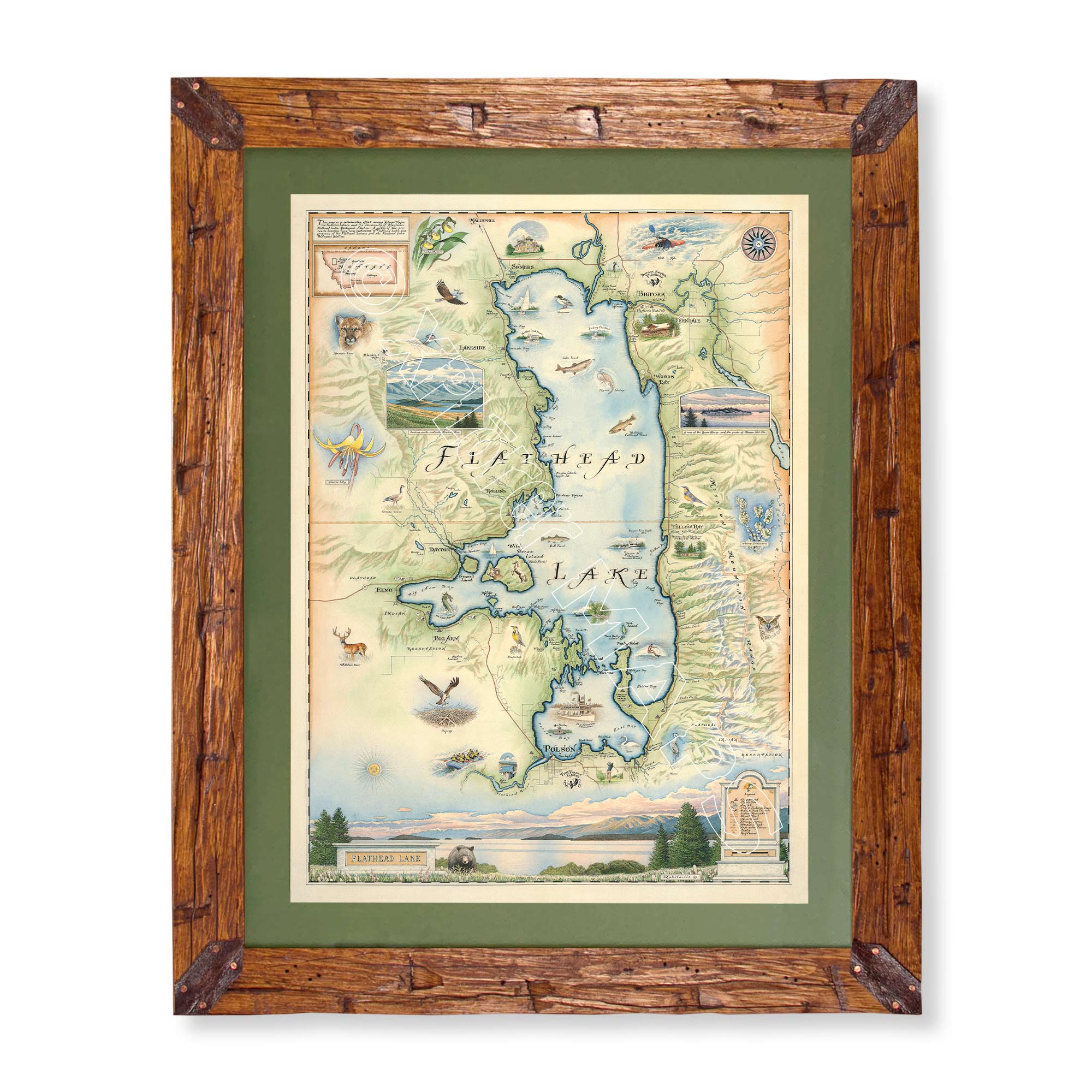
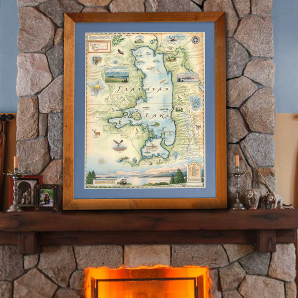
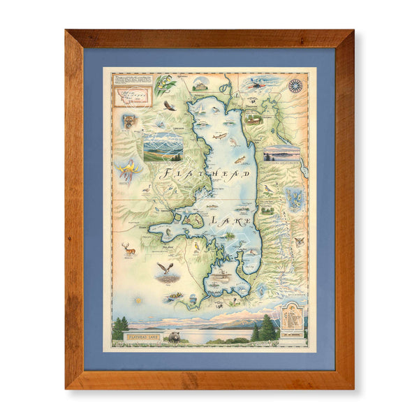
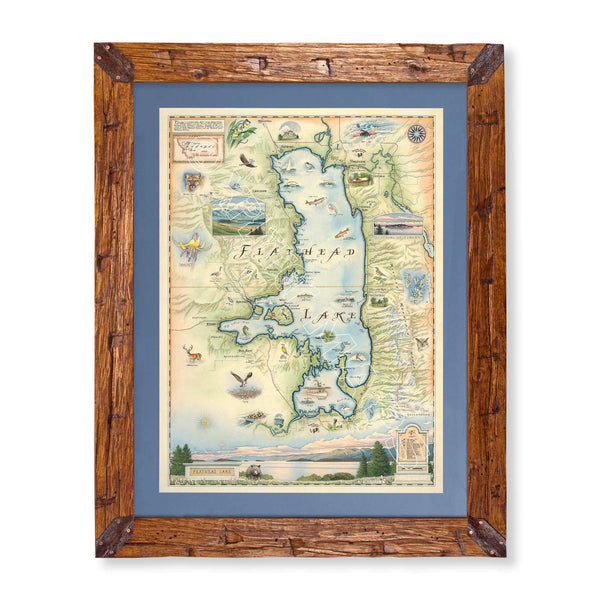
Original hand-drawn pen and ink/watercolor story map that encapsulates a true gem for recreation, landscape and wildlife in Montana, Flathead Lake. The map captures the unique beauty of Flathead Lake sitting at the base of Mission Mountain Range to the south, and stretching north to border the picturesque Swan Valley and Swan Range as well as the peaks of Glacier National Park, both combined creating a breathtaking backdrop of the eastern shore of the lake.
The map also highlights two distinct sections of the lake to the north and south. The northern half features major towns such as Kalispell, Somers featuring the historic Somers Mansion and Bigfork, a popular summer home of the Kayaking Festival and theater at the Bigfork Summer Playhouse. Bigfork is situated between the mouth of the Flathead River as it enters Flathead Lake and the Swan River as it flows into the lake. Opposite of Bigfork on the southern half of the lake, located on the Flathead Reservation of the Confederated Kootenai and Salish Tribes (from which combined, the lake’s name derives) is the major town town of Polson located right at the drainage of the Flathead River through Seli'š Ksanka Qlispe' Dam, formerly known as Kerr Dam.
Not only does the map verify the grandeur of the lake’s landscape, but it celebrates the endless opportunities for recreation and as well as types of plants and wildlife that bring people from all over the world to the lake such as: water skiing, boating, kayaking, sailing, fishing, rafting, hiking, camping and skiing. The flora and fauna within and surrounding the lake includes Meadowlark, Heron, Lake Trout, Bald Eagles, Mountain Lions, Glacier Lilies, Lady’s Slippers, Cherry Blossoms and more.
This project is a unique and exciting collaboration among Xplorer Maps, Flathead Lakers and the University of Montana's Flathead Lake Biological Station. Our objectives are to help raise awareness and funds for these two organizations that have invested so much in the future of the lake and have proven to be exemplary stewards of its resources.
Xplorer Maps released 300 signed and numbered Limited Edition Giclee Prints of the Flathead Lake Map in the summer of 2012 of which all were sold out. However, the lithographic prints will continue to be sold. Xplorer Maps has donated more than $16,000 from the sale of these prints as well as the original artwork to the above organizations to help with ongoing water quality monitoring, community education and conservation related products.
The Flathead Lake Map is 18" wide and 24" tall.
Are you looking for a custom matted and framed piece? Pick from Montana hand-scraped pine or reclaimed Flathead Lake larch. In addition, you can choose between green or blue mats.
* The framed map is for retail purchase only. Xplorer Maps does not offer wholesale pricing on framed maps.
Montana's Flathead Lake larch Frame - 10%of the larch logs originally intended as railroad ties for the Great Northern Railroad sunk to the bottom of Flathead Lake, MT. These over 100-year-old logs have been dive-located, dredged, dried, cured, planed, scraped, sawn, sanded, and shaped into reclaimed heritage wood frames exclusively for Xplorer Maps.
Hand-Scraped Montana Pine - Montana forest-harvested pine frame. For that rustic look, each frame is hand-scraped.
All frames are equipped with conservation clear glass, which is guaranteed to block 99% of ultraviolet rays. Upgrade to Museum glass, which ensures 99% UV protection but also provides ZERO GLARE - this is the quality glass you would find in gallery settings.
Our on-line store is open 24/7 and we ship Monday through Friday, excluding some holidays. Orders received for products without shipping restrictions on its product page will ship the same business day when received before 12:00 p.m. PST. Orders in high demand will have an estimated production time listed on its product page and will ship according to the date listed.
The Xplorer Maps Warehouse Team strives to ship every order within 1 business day.
For custom orders (including framing), please allow 3-4 weeks for shipping.
Xplorer Maps ships all over the world, but prices and shipping times vary according to state, country, and the weight of items purchased. International recipients are solely responsible for any fees such as, but not limited to, VAT or import duties.
All prices will be charged according to your destination at check-out. This information is shown before your credit card is charged and you can click on the "calculate shipping charges" once an item has been placed in the cart to see the exact shipping based on your zip code.
We ship with UPS and USPS. Expedited shipping options are available at checkout.
Please be aware that despite our prompt shipping, factors beyond our control may occasionally lead to delays in the arrival of your order. For additional questions regarding shipping please email us at: warehouse@xplorermaps.com
Beautiful map. My husband was very happy. We had it framed. Thank you!
Mounted on a Foam Board! Great detail, Color’s and Style…
Happy Camper… Flathead Lake
Beautiful and just as expected. Nice weight of poster paper. Can’t wait to frame and put in my niece’s new Flathead cabin.
Email: Info@xplorermaps.com
Brick-and-Mortar Address: 1245 S 3rd ST W; Missoula, MT 59801
Phone: 406-546-4972
Warehouse Address: 500 S Inez ST; Missoula MT 59801
© 2024, Xplorer Maps


